
Monsoon watch
The wettest stretch of the year, on paper
By Genext Information Systems Staff
Published 26 July 2026 • 6 min read
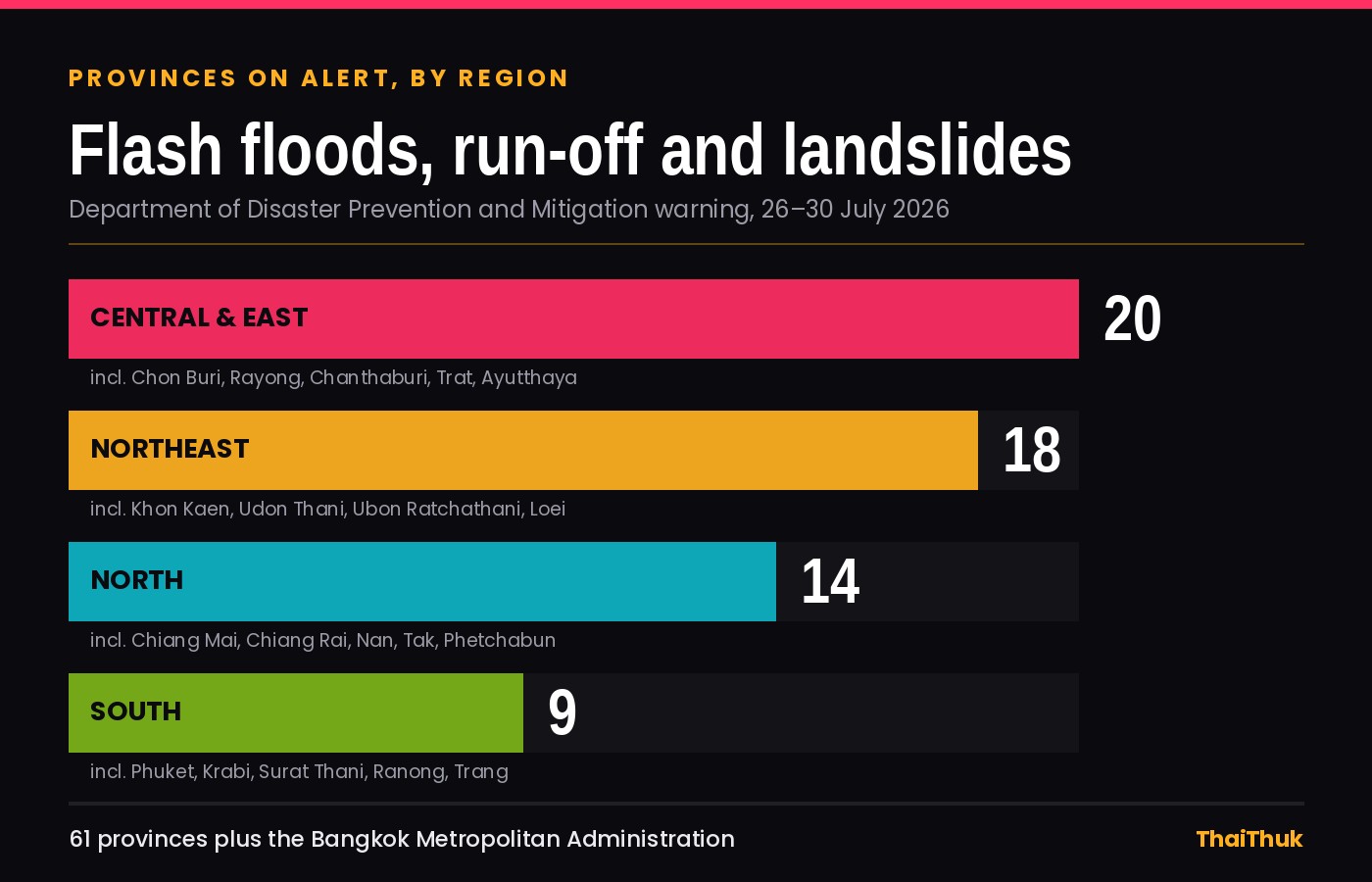
Thailand's Department of Disaster Prevention and Mitigation issued its warning on Friday 24 July, and by Sunday morning it had been upgraded from a piece of paperwork into the story of the week. Sixty-one provinces, plus the Bangkok Metropolitan Administration, are on alert for forest run-off, flash floods, waterlogging and landslides between 26 and 30 July. That is very nearly the entire country: Thailand has 77 provinces.
Warnings like this are routine between June and October, and a five-day alert is not a national emergency. It is, though, useful information: it tells you which parts of the country are about to become inconvenient, which activities may be shut down without notice, and where the sea will be too rough to sail on.
What the DDPM has actually said
Two weather systems, five days, and almost every province in the country.
DDPM director-general Teerapat Katchamat said the Central Disaster Prevention and Mitigation Command issued the alert after assessing the forecast alongside other risk factors — river levels, saturated ground, and catchments that have already taken a month of monsoon rain.
The forecast behind it is the Thai Meteorological Department's second heavy-rain announcement, issued at 5am on 24 July. It predicts isolated heavy rain nationwide for the five days, with very heavy downpours possible in the East and along the southern west coast.
Two systems are driving it. A monsoon trough is lying across the upper North, Laos and northern Vietnam, dragging moisture over the top of the country, while the southwesterly monsoon has strengthened over the Andaman Sea, Thailand and the Gulf. That combination is what turns an ordinary wet week into one with flash-flood risk attached.
The instruction to provincial offices tells you what officials expect: monitor rainfall and water levels around the clock, pre-position emergency crews and machinery in high-risk areas, and warn residents early.
The alert in numbers
- 61 — provinces on watch, plus Bangkok
- 5 — days covered, 26 to 30 July
- 3 m+ — possible wave height in the upper Andaman
- 1784 — the 24-hour DDPM disaster hotline
Where the risk is concentrated
Almost everywhere is listed. Not everywhere is equally exposed.
Fourteen Northern provinces are named, among them Mae Hong Son, Chiang Mai, Chiang Rai, Nan, Tak and Phetchabun — mountain country where the danger is less about standing water than about how fast it arrives. Steep catchments turn a heavy afternoon into a wall of brown water in a valley an hour later, and landslides close roads with no warning at all.
Eighteen Northeastern provinces are listed, from Loei and Nong Khai along the Mekong down through Khon Kaen, Roi Et and Ubon Ratchathani. Twenty Central and Eastern provinces stretch from Kanchanaburi and Ayutthaya across to Chon Buri, Rayong, Chanthaburi and Trat — which puts Pattaya, the Rayong beaches and the Koh Chang crossing inside the warning area.
Nine Southern provinces complete it: Chumphon, Surat Thani, Nakhon Si Thammarat and Phatthalung on the Gulf side, and Ranong, Phang Nga, Phuket, Krabi and Trang facing the Andaman. Bangkok's alert extends to five neighbouring provinces — Pathum Thani, Nonthaburi, Nakhon Pathom, Samut Sakhon and Samut Prakan.
The part that cancels boats
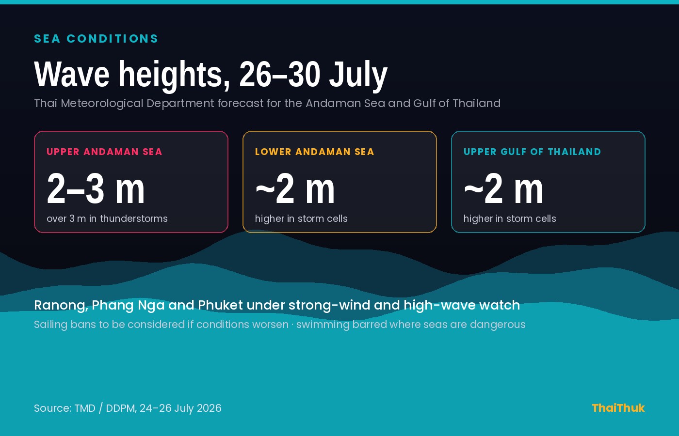
For anyone with an island ferry booked, the marine section of the warning matters more than the rain. The TMD expects waves of two to three metres in the upper Andaman Sea, rising above three metres inside thunderstorms, with roughly two-metre seas in the lower Andaman and the upper Gulf.
Ranong, Phang Nga and Phuket are under a specific strong-wind and high-wave watch, covering Mueang, Suk Samran and Kapoe in Ranong, Ko Yao, Takua Thung, Thai Mueang, Takua Pa and Khura Buri in Phang Nga, and every district of Phuket. Authorities have been told to issue coastal warnings and stop tourists swimming where conditions are dangerous; boat operators have been asked to take greater care, with sailing bans to be considered if the forecast worsens.
Waterfalls, caves and the closure rule
One line in the DDPM's instructions is aimed squarely at visitors. Officials have been told to pay particular attention to natural attractions — caves, waterfalls and cave passages — and to close them and restrict access whenever conditions present a danger.
This is the most likely way the warning touches a holiday. Waterfall parks in Kanchanaburi, Chanthaburi, Chiang Mai and Phang Nga can close on a few hours' notice, and caves close faster still, because the water inside can rise long before anything looks wrong from the car park. If a park gate is shut, the ranger on it is not negotiating.
Keep the day flexible: check with the park office or your guesthouse on the morning rather than the night before, and have an alternative ready. Temples, markets, cooking classes and museums do not close for rain.
Travelling through a monsoon week
Download the THAI DISASTER ALERT app if you are travelling in the North or on either coast; it carries official notices ahead of the news cycle. The DDPM's 1784 hotline runs 24 hours.
Build slack into travel days. Flash flooding closes provincial roads for hours rather than days, but four hours will still cost you a flight — treat a same-day ferry-plus-flight combination as optimistic.
Do not ride into standing water of unknown depth. The most common serious incident of a Thai monsoon week is not a dramatic flood but a rented motorbike finding a submerged pothole or an open drain. In Bangkok the flooding after a heavy afternoon is usually measured in centimetres and hours, and the BTS and MRT keep running regardless.
Finally, this is the season, not an aberration. Rain in July and August is why hotel rates are low and why the countryside is green. It rarely rains all day; it rains hard, and then it stops.
A warning, not a washout
Five days of isolated heavy rain across a country this size will produce some bad afternoons in a handful of places, a lot of unremarkable wet weather everywhere else, and cancelled boats along the Andaman coast. That is roughly what the last week of July usually looks like.
The value of the DDPM notice is its specificity: it names the provinces, the sea areas and the attractions most likely to close. If you are in one of the 61, keep plans loose until Thursday, stay out of the water on the west coast, and check before driving to a waterfall. If you are not, you will probably just get rained on.
Plan it before you book it
Green season travel, costed honestly
Low-season rates, ferry crossings, transfers and the wet-weather day you did not plan for all change what a trip costs. ThaiHolidayBudget prices a Thailand trip on 2026 numbers, and ThaiTripPlanner will build the days around the weather.
Price out your trip →
Written by
Genext Information Systems Staff
ThaiThuk's editorial team at Genext Information Systems — writers and long-term residents based in Thailand who report from the ground on Thai culture, travel, food and community. Every piece is checked against primary sources and updated as details change. More about ThaiThuk →
Sources
- Department of Disaster Prevention and Mitigation — alert covering 61 provinces for 26–30 July 2026, issued 24 July 2026.
- Thai Meteorological Department — second heavy to very heavy rain announcement, 5am, 24 July 2026.
- The Nation Thailand and The Thaiger — reporting on the DDPM warning, 25 and 26 July 2026.
Forecasts change. Check the TMD, the THAI DISASTER ALERT app or the 1784 hotline for the current position before travelling.